Showing posts with label beach. Show all posts

Thursday, May 16, 2013

Topsail Hill Preserve State Park


places where you won't be able to wipe the wag off your dog's tail - Santa Rosa Beach FL


The Park
Topsail Hill is the most intact coastal ecosystem in all of Florida. The state moved to protect this unique natural area by purchasing 1,637 acres here in 1992. There are 14 identifiable ecosystems, including freshwater coastal dune lakes, wet prairies, scrub, pine flatwoods, marshes, cypress domes, seepage slopes and 3.2 miles white sand beaches - the remnants of quartz washed down from the Appalachian Mountains. Topsail Hill gets its name from the landmark 25-foot high dune that resembles a ship’s topsail.

The Walks
Topsail Hill is the best place that you can take your dog for an extended hike along the Gulf of Mexico. The trail of choice is the Morris Lake Nature Trail, a 2.5-mile balloon route laid out through ancient coastal dunes. The dunes trail is wide open and exposed to the elements so bring plenty of water for your dog on a hot day and since every step of the way is across glistening white soft sugar sand, your dog will get a workout any time of the year. In fact, look for iron tracks laid down during World War II that allowed heavy trucks to travel across the thick sand when these dunes were used as a bombing range. Morris Lake is one of three freshwater coastal dune lakes on the property. These rare oases are found only along the Gulf Coast in America and while tempting to visit for your dog, are inhabited by alligators. The trail climbs briefly into a Florida shrub community where your dog can find some shade among the sand pines and shrubby oaks before finishing along the Gulf of Mexico beach. If your dog isn’t spent from an hour on the Morris Lake dunes there is more hiking available in the other direction to Campbell Lake. This trail can also be accessed from the main entrance and campground and your dog won’t be allowed to finish the entire 5.2-mile loop (it tracks along the beach) but she can reach the broad, flat lakeside.

Where The Paw Meets The Earth: A trailmap and interpretive brochure can be found at the trailhead and directional signs decipher the faceless dunes.
Workout For Your Dog - Several hours possible.
Swimming - Alligators live in the lake.
Restrictions On Dogs - Dogs are allowed on the trails and in the campground but not on the beach.

Something Extra
In the days of sailing ships, turpentine was critical to the upkeep and preservation of wooden boats. The word turpentine derives from the terebinth tree, from whose sap the spirit was originally distilled. In early America, the tree of choice for turpentine was the old growth longleaf pines found across the South. To get the sap to flow, a deep V or “cat face” is cut into the side of a tree and gathered in a clay pot hung from a nail in the tree. The sap is then boiled and the turpentine residue collected. You can see cat face scars on trees still living in the preserve.

Phone - (850) 267-0299
Admission Fee - Vehicle entrance fee
Directions - Santa Rosa Beach; the main entrance is on CR 30A, one mile east of US 98, but the entrance of choice for most dog owners will be via Topsail Road from US 98, west of the junction with CR 30A.


The Hiking With Dogs group on Facebook is the place to post photos and info on your favorite canine hikes. Also get questions answered and find advice from members: join now

Wednesday, April 24, 2013

Assateague National Seashore


places where you won't be able to wipe the wag off your dog's tail - Berlin MD


The Park
The first European settlers - a band of four men - came to Assateague in 1688. At times more than 200 people survived on the shifting sands, fishing or clamming or growing what crops they could. In 1833 the first lighthouse was built but ships still ran aground, including the Dispatch, the official yacht of five American presidents. The cruiser was ruined beyond repair when it reached the shore unscheduled on October 10, 1891. Assateague was connected to the mainland until 1933 when an August hurricane tore open an inlet to the Sinepuxent Bay that now separates Assateague from Ocean City. A bridge to the mainland opened in 1962 and in 1965 Assateague Island became a national seashore.

The Walks
Dogs are not allowed on the three short channel-side nature trails and can not go on lifeguarded beaches but that leaves miles of wide, sandy beaches to hike on with your dog any time of the year. Drive to the furthest parking lot from the entrance gate and head up the boardwalk across the dunes. Make a right and ahead of you will stretch hours of unspoiled canine hiking in the surf and sand. Although the national seashore is within a few hours’ drive of tens of million of Americans don’t be surprised if you have most of this beach to yourself and your dog - especially in the off-season.

Where The Paw Meets The Earth: Sand
Workout For Your Dog - Yes, hiking in sand is tough
Swimming - Absolutely - but pack your own sticks for the dog; not much driftwood stays on the beach
Restrictions On Dogs - Yes in campground but no on the nature trails, the sand north of the national seashore in the adjoing Assateague State Park is off limits to dogs 

Something Extra
Assateague Island is the famous home of the free-roaming “Chincoteague Ponies,” a present-day reminder of Assateague Island’s past. Although no one is certain when or how the ponies first arrived on the island, a popular legend tells of ponies that escaped a shipwrecked Spanish galleon and swam ashore. However, most historians believe that settlers used the island for grazing livestock (including ponies and other farm animals) in the 17th Century to avoid fencing regulations
and taxation. The ponies rule the island and you can see them on the roads or even meet them in the surf.

Phone - (301) 874-2024
Admission Fee - Yes, good for 7 days
Directions - Berlin, Worcester County; north entrance is at the end of MD 611, eight miles south of Ocean City. When coming on to the island turn right and avoid going straight into the state park. No dogs allowed there.


The Hiking With Dogs group on Facebook is the place to post photos and info on your favorite canine hikes. Also get questions answered and find advice from members: join now

Saturday, April 6, 2013

The Greenway


places where you won't be able to wipe the wag off your dog's tail - Block Island RI


The Park
Back in 1972 Block Islanders looked around and noticed houses going up at an alarming rate. Captain John Robinson “Rob” Lewis led a small group to form the Block Island Conservancy with the modest goal to just save Rodman’s Hollow, a precious glacial outwash basin. They were able to raise enough money to preserve this region of maritime scrubland. Hundreds of islanders donated money and the conservation movement flourished. Over the years some land was donated and more made available below market value. Today over 40% of Block Island is protected from future development. So effective were the efforts of the Conservancy that the Nature Conservancy designated Block Island as one of its original “Last Great Places” in the Americas.

The Walks
Take away the ferry ride and the half-hour walk along shoulder-less - and sometimes busy - two lanes road and The Greenway would be the finest place in Rhode Island to hike with your dog. What is your dog interested in? Open fields? Sporty hills? Long vistas? A romp on the beach? A swim in a pond? Unique woodlands? The Greenway has them all. There are about 12 miles of footpaths crisscrossing the southern half of Block Island in the tradition of walking the English countryside. In addition to paw-friendly mown grass and soft dirt trails you will need to go down dirt roads and paved streets to get to some trailheads. To reach the beach use Black Rock Road in Rodman’s Hollow. If you find yourself with your dog walking along Mohegan Trail/Spring Street you can descend a flight of wooden stairs to the beach at the foot of the spectacular Mohegan bluffs from Payne Overlook.

Where The Paw Meets The Earth: Your first stop on Block Island should be in the Visitor Center on the dock to buy a trail map for a small fee. This will show you the way to the trailheads. Signs are posted at some trailheads and along the trails.
Workout For Your Dog - Allow a full day of canine hiking to explore The Greenway.
Swimming - There are 17 miles of public beaches on Block Island so your dog will get an ocean swim. Crescent Beach, a few pawprints from the ferry landing, is the most convenient but crowded in-season. As the new arrivals fan out from the ferry the beaches offer more room for your dog. One beach that is too small for sun worshippers but ideal for dogs is just south of Old Harbor along Spring Street - as you reach the crest of a hill drop down to the sand in front of a guardrail for great canine swimming along a breakwater.
Restrictions On Dogs - Block Island is a dog-friendly island - don’t come without him!

Something Extra
Block Island supports some 40 rare or endangered species. One that is found only in Rodman’s Hollow, in huge kettleholes gouged by Godzilla-sized chunks of glacial ice that melted, is the Block Island Meadow Vole, first discovered in 1908. It is part of the magic of the island that it is a thrill here to see rodents considered vermin on the mainland. It’s not easy to see a brown-and-black vole but you may see their tunnel-like trails through the grass.

Phone Number - (401) 466-5675
Admission Fee - None (ferry fee may be necessary; dogs sail for free)
Directions -The Nature Conservancy office on Block Island is on High Street, straight ahead out of Old Harbor.


The Hiking With Dogs group on Facebook is the place to post photos and info on your favorite canine hikes. Also get questions answered and find advice from members: join now

Thursday, April 4, 2013

Topsail Hill Preserve State Park


places where you won't be able to wipe the wag off your dog's tail - Santa Rosa Beach FL


The Park
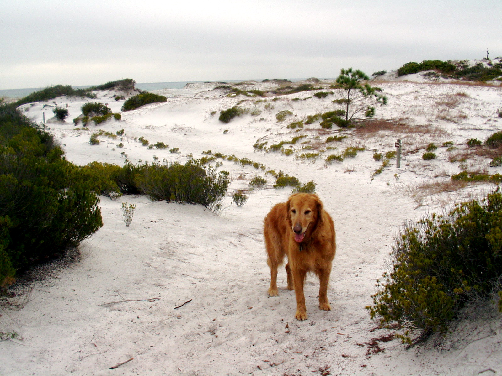
Topsail Hill is the most intact coastal ecosystem in all of Florida. The state moved to protect this unique natural area by purchasing 1,637 acres here in 1992. There are 14 identifiable ecosystems, including freshwater coastal dune lakes, wet prairies, scrub, pine flatwoods, marshes, cypress domes, seepage slopes and 3.2 miles white sand beaches - the remnants of quartz washed down from the Appalachian Mountains. Topsail Hill gets its name from the landmark 25-foot high dune that resembles a ship’s topsail.

The Walks
Topsail Hill is the best place that you can take your dog for an extended hike along the Gulf of Mexico. The trail of choice is the Morris Lake Nature Trail, a 2.5-mile balloon route laid out through ancient coastal dunes. The dunes trail is wide open and exposed to the elements so bring plenty of water for your dog on a hot day and since every step of the way is across glistening white soft sugar sand, your dog will get a workout any time of the year. In fact, look for iron tracks laid down during World War II that allowed heavy trucks to travel across the thick sand when these dunes were used as a bombing range. Morris Lake is one of three freshwater coastal dune lakes on the property. These rare oases are found only along the Gulf Coast in America and while tempting to visit for your dog, are inhabited by alligators. The trail climbs briefly into a Florida shrub community where your dog can find some shade among the sand pines and shrubby oaks before finishing along the Gulf of Mexico beach. If your dog isn’t spent from an hour on the Morris Lake dunes there is more hiking available in the other direction to Campbell Lake. This trail can also be accessed from the main entrance and campground and your dog won’t be allowed to finish the entire 5.2-mile loop (it tracks along the beach) but she can reach the broad, flat lakeside.

Where The Paw Meets The Earth: A trailmap and interpretive brochure can be found at the trailhead and directional signs decipher the faceless dunes.
Workout For Your Dog - Several hours possible
Swimming - Alligators live in the lake but your dog can step in to cool off.
Restrictions On Dogs - Dogs are allowed on the trails and in the campground but not on the beach.

Something Extra
In the days of sailing ships, turpentine was critical to the upkeep and preservation of wooden boats. The word turpentine derives from the terebinth tree, from whose sap the spirit was originally distilled. In early America, the tree of choice for turpentine was the old growth longleaf pines found across the South. To get the sap to flow, a deep V or “cat face” is cut into the side of a tree and gathered in a clay pot hung from a nail in the tree. The sap is then boiled and the turpentine residue collected. You can see cat face scars on trees still living in the preserve.

Phone Number - (850) 267-0299
Admission Fee - Vehicle entrance fee
Directions - Santa Rosa Beach; the main entrance is on CR 30A, one mile east of US 98, but the entrance of choice for most dog owners will be via Topsail Road from US 98, west of the junction with CR 30A.


The Hiking With Dogs group on Facebook is the place to post photos and info on your favorite canine hikes. Also get questions answered and find advice from members: join now

Wednesday, April 3, 2013

Corson’s Inlet State Park


places where you won't be able to wipe the wag off your dog's tail - Ocean City NJ


The Park
Corson’s Inlet was established in 1969 before every last inch of Jersey shorefront became developed. With its undisturbed sand dune systems and marine estuaries this is one of your last opportunities to experience the Atlantic oceanfront in New Jersey as it was before people discovered the shore.

The Walks
There aren’t many places where the hiking public is invited to walk across protected ocean dunes but Corson’s Inlet is one. Even rarer still is to find a dune system that permits dogs and again Corson’s Inlet is the place - from September 16 through March 31. The main trail (Yellow) leading away from the small parking lot beside the Rush Chattin Bridge between Ocean City and Strathmere and its two spur paths (Orange, then Red) all lead to the beach that can be used to create loop hikes on the hook-shaped peninsula. All canine hiking is on deep sugar sand and the trails are just long enough to be enjoyable without becoming laborious. If you come to Corson’s Inlet in late September or October on a hot day make sure to bring plenty of fresh water for your dog. Even though the trails aren’t long there is little shade among the dunes.

Where The Paw Meets The Earth: Sand
Workout For Your Dog - Yes, with ocean swimming and running in sand
Swimming - If the excitement of the Atlantic surf is too intimidating try the expansive crescent beach along the inlet with its calm, inviting waters
Restrictions On Dogs - No dogs between April 1 and September 15

Something Extra
America’s second-worst fire took place on a steamship called the General Slocum on New York’s East River in 1904 - more than 1,000 people perished. The steamer was salvaged and put back into service as a barge called the Maryland that sank off Corson’s Inlet on December 11, 1911. Buried beneath several feet of shifting sand searchers believe they have located the infamous General Slocum but there has been no definitive recovery.

Phone - (609) 861-2404
Admission Fee - None
Directions - Ocean City, Cape May County; from the Garden State Parkway use Exit 82 - Route 37 East/Seaside Heights. Take the jughandle to Fischer Boulevard and head north. Go right at the fourth light onto Cattus Island Boulevard; parking lot is on the left.


The Hiking With Dogs group on Facebook is the place to post photos and info on your favorite canine hikes. Also get questions answered and find advice from members: join now

Saturday, March 30, 2013

North Brigantine Natural Area


places where you won't be able to wipe the wag off your dog's tail - Brigantine NJ


The Park
The Brigantine Bay and marsh complex includes the open water and tidal wetlands of, from north to south: Little Bay, Reed Bay, Somers Bay, Absecon Bay and Channel, Lakes Bay, and Scull Bay between the mainland coast of New Jersey and the barrier islands from Little Egg Inlet southwest to Great Egg Harbor Inlet. The complex includes the undeveloped segments of Little Beach and northern and southern Brigantine Island. This portion of the New Jersey backbarrier lagoon estuarine system is very significant for migrating and wintering waterfowl, colonial nesting waterbirds, migratory shorebirds, and fisheries.

The Walks
It may change due to concerns about nesting plovers but this undeveloped area at the northern tip of Brigantine is open to dogs. You can hike north on the shore, ducking out of the way of surf fishermen, and take the hook along the inlet and head back. If the Atlantic waves are too intimidating for your dog, the gentle surf of the bay will be a perfect place to swim. This entire hike up and back - completely on sand - will take about an hour if you keep moving and don’t linger for too many swims.

Where The Paw Meets The Earth: Sand
Workout For Your Dog - Racing on sand and jumping in the ocean will tire any dog
Swimming - Absolutely
Restrictions On Dogs - None

Something Extra
This is a rare Jersey shore destination for dogs throughout the year.

Phone - None
Website - None
Admission Fee - None
Directions - Brigantine, Atlantic County; take Route 30 into Atlantic City from Route 9 and head north on Brigantine Boulevard through town and all the way to the end.


The Hiking With Dogs group on Facebook is the place to post photos and info on your favorite canine hikes. Also get questions answered and find advice from members: join now

Saturday, March 23, 2013

First Landing State Park


places where you won't be able to wipe the wag off your dog's tail - Virginia Beach VA


The Park
In 1873 a U.S. Weather Bureau Observation Center was established at Cape Henry and the next year a U.S.
Life Saving Station was built. A small community grew up around the stations and it seemed like the area was about to boom. A group of Norfolk investors formed the Cape Henry Syndicate to encourage development but the popularity of Virginia Beach down the road never materialized. In 1933 the Syndicate sold 2,000 acres to the Commonwealth of Virginia for $157,000. Federal Civilian Conservation Corps workers arrived and built
Seashore State Park, one of Virginia’s original six state parks. The park’s name was changed in 1997 to First Landing State Park as an homage to the first place where members of the Virginia Company landed in 1607.

The Walks
The trail system at First Landing State Park, designated as part of the National Recreation Trail System, features 19 miles of dog-friendly hiking. The marquee walk is the Bald Cypress Trail that circles a cypress swamp for 1.5 miles, much of the way on elevated boardwalks. Airborne Spanish moss drapes many of the ancient giants. In 1965 the park’s natural area was included in the National Register of Natural Landmarks because of its distinction as the northernmost location on the East Coast where subtropical and temperate plants grow and thrive together, darkening the trails with their richness. Looping off the redblazed Bald Cypress Trail is the 3.1-mile blue Osmanthus Trail, named for the American olive tree that grows abundantly on the fringes of the dark lagoon along the trail. Another worthwhile detour from the Bald Cypress Trail is the quarter-mile High Dune Trail that uses wooden sleeper-steps to ascend a steep, wooded dune. It is easy walking on these packed sand and soft dirt trails that are further cushioned to the paw by pine straw from majestic loblolly pines. There are gentle undulations that spice up the flat canine hiking along the 8 hiker-only trails and the 6-mile Cape Henry Multi-Use Trail.

Where The Paw Meets The Earth: Everything is marked, signs abound and most everything leads back to the Trail Center.
Workout For Your Dog - Up to a half-day or more.
Swimming - It doesn’t get much better than the Chesapeake Bay for canine aquatics.
Restrictions On Dogs - Dogs are allowed on the trails and on the beach that stretches along the Chesapeake Bay, except in swimming areas.

Something Extra
Just off-shore are views of the Chesapeake Bay Bridge-Tunnel, one of the seven modern engineering marvels of the world. Each span of the 17.6-mile crossing utilizes more than 2,500 concrete piles to support the trestles. Construction of the bridge-tunnel complex required undertaking a project of more than
12 miles of low-level trestles, two 1-mile tunnels, two bridges, almost 2 miles of causeway, four manmade islands and 5-1/2 miles of approach roads, totaling 23 miles.

Phone - (757) 412-2300
Admission Fee - Vehicle entrance fee
Directions - Virginia Beach; From I-64, take Northampton Boulevard/ U.S. 13 North (Exit 282). Go through 8 lights, then turn right at the Shore Drive/U.S. 60 Exit (last exit before the Chesapeake Bay Bridge Tunnel). Take a right on Shore Drive and go 4.5 miles to the park entrance. For the Trail Center and trails, turn right.


The Hiking With Dogs group on Facebook is the place to post photos and info on your favorite canine hikes. Also get questions answered and find advice from members: join now