Showing posts with label trail. Show all posts

Wednesday, May 8, 2013

Fort DuPont State Park


places where you won't be able to wipe the wag off your dog's tail - Delaware City DE


The Park
On the shore opposite Fort Delaware, Fort DuPont was actively garrisoned during the Civil War and the Spanish-American War; used as a training base in World War I; and detained German prisoners in World War II. It is named for Samuel Francis du Pont who, during the Civil War commanded a fleet of 77 vessels and 12,000 men to a critical Union victory in the Battle of Port Royal Sound. It was the largest United States naval expeditionary force ever assembled up to that time.

The Walks
The 1-mile River View Trail loop begins a gently sloping canine hike in the marshland along the Delaware River and finishes in shaded woodlands. If you walk it backwards you have longer sustained views of the river and Fort Delaware on Pea Patch Island. The grass trail takes you past several ruins of the military installation, camoflaged to river traffic.

Where The Paw Meets The Earth: Paw-friendly grass
Workout For Your Dog - Easy canine hike in the old military base
Swimming - There is a small section of the park where a really water-starved dog can reach the Delaware River but it is not a beach.
Restrictions On Dogs - None

Something Extra
The heronry on Pea Patch Island (the story goes that in colonial times a boat hauling peas ran aground on this 178-acre mud flat spilling its cargo and planting a pea patch) is the largest Atlantic Coast nesting ground north of Florida for wading birds. There is ample opportunity to watch ibis, egrets and herons - who live in pairs - go about their lives in the Delaware River.

Phone - (302) 834.7941
Website - http://www.destateparks.com/fdsp/fdpp.htm
Admission Fee - Yes, May to October
Directions - Delaware City, New Castle County; the main parking lot is in the back of the Governor Bacon Health Center. The entrance is off Route 9 on the south side of the Delaware City Branch Canal. The trailhead is directly behind the small parking lot.


The Hiking With Dogs group on Facebook is the place to post photos and info on your favorite canine hikes. Also get questions answered and find advice from members: join now

Monday, April 15, 2013

Elk Neck State Park


places where you won't be able to wipe the wag off your dog's tail - Northeast MD


The Park
At Turkey Point the Northeast and Elk rivers have pinched a finger of land in the Upper Chesapeake Bay so violently that it swells to more than 100 feet above the water. The result is Elk Neck State Park, a vibrant mix of sandy beaches, marshlands and hardwood forests.

The Walks
There are five main trails at Elk Neck State Park. None is longer than two miles and all can be covered in a leisurely afternoon of canine hiking. The White Trail through the Thackery Swamp is a self-guiding nature trail. The Black Trail skirts the shoreline of the Elk River and the waters of the Chesapeake Bay can be reached from the Blue Trail at Turkey Point. You start your explorations on an old access road high above the waters that soon turns towards the Old Turkey Point Lighthouse. The various footpaths radiate off the main trail across the peninsula.

Where The Paw Meets The Earth: Dirt roads and woods paths
Workout For Your Dog - Gradual climbs to Turkey Point
Swimming - Spirited dog swimming on small sandy beaches on the Chesapeake Bay
Restrictions On Dogs - No dogs on the North East Beach

Something Extra
A lighthouse was authorized by Congress in 1831 and two years later a tower and keeper’s quarters was situated on a 100-foot bluff where the North East and Elk Rivers converge. Originally, the 35-foot tower had a panel of red glass to warn ships they were approaching the shallows. The beacon was visible for 13 miles and was the highest of 74 lighthouses on the Chesapeake Bay. The keeper’s quarters are gone but the tower and spectacular views remain atop the grassy bluffs.

Phone - (410) 287-5333
Admission Fee - None
Directions - Northeast, Cecil County; from I-95 exit onto Route 272 (North East Road)and go south 2.4 miles to Route 7 (East Cecil Avenue). Cross State Route 7, stay on Route 272 and go 11 miles to the end of the road and the park.


The Hiking With Dogs group on Facebook is the place to post photos and info on your favorite canine hikes. Also get questions answered and find advice from members: join now

Saturday, April 6, 2013

The Greenway


places where you won't be able to wipe the wag off your dog's tail - Block Island RI


The Park
Back in 1972 Block Islanders looked around and noticed houses going up at an alarming rate. Captain John Robinson “Rob” Lewis led a small group to form the Block Island Conservancy with the modest goal to just save Rodman’s Hollow, a precious glacial outwash basin. They were able to raise enough money to preserve this region of maritime scrubland. Hundreds of islanders donated money and the conservation movement flourished. Over the years some land was donated and more made available below market value. Today over 40% of Block Island is protected from future development. So effective were the efforts of the Conservancy that the Nature Conservancy designated Block Island as one of its original “Last Great Places” in the Americas.

The Walks
Take away the ferry ride and the half-hour walk along shoulder-less - and sometimes busy - two lanes road and The Greenway would be the finest place in Rhode Island to hike with your dog. What is your dog interested in? Open fields? Sporty hills? Long vistas? A romp on the beach? A swim in a pond? Unique woodlands? The Greenway has them all. There are about 12 miles of footpaths crisscrossing the southern half of Block Island in the tradition of walking the English countryside. In addition to paw-friendly mown grass and soft dirt trails you will need to go down dirt roads and paved streets to get to some trailheads. To reach the beach use Black Rock Road in Rodman’s Hollow. If you find yourself with your dog walking along Mohegan Trail/Spring Street you can descend a flight of wooden stairs to the beach at the foot of the spectacular Mohegan bluffs from Payne Overlook.

Where The Paw Meets The Earth: Your first stop on Block Island should be in the Visitor Center on the dock to buy a trail map for a small fee. This will show you the way to the trailheads. Signs are posted at some trailheads and along the trails.
Workout For Your Dog - Allow a full day of canine hiking to explore The Greenway.
Swimming - There are 17 miles of public beaches on Block Island so your dog will get an ocean swim. Crescent Beach, a few pawprints from the ferry landing, is the most convenient but crowded in-season. As the new arrivals fan out from the ferry the beaches offer more room for your dog. One beach that is too small for sun worshippers but ideal for dogs is just south of Old Harbor along Spring Street - as you reach the crest of a hill drop down to the sand in front of a guardrail for great canine swimming along a breakwater.
Restrictions On Dogs - Block Island is a dog-friendly island - don’t come without him!

Something Extra
Block Island supports some 40 rare or endangered species. One that is found only in Rodman’s Hollow, in huge kettleholes gouged by Godzilla-sized chunks of glacial ice that melted, is the Block Island Meadow Vole, first discovered in 1908. It is part of the magic of the island that it is a thrill here to see rodents considered vermin on the mainland. It’s not easy to see a brown-and-black vole but you may see their tunnel-like trails through the grass.

Phone Number - (401) 466-5675
Admission Fee - None (ferry fee may be necessary; dogs sail for free)
Directions -The Nature Conservancy office on Block Island is on High Street, straight ahead out of Old Harbor.


The Hiking With Dogs group on Facebook is the place to post photos and info on your favorite canine hikes. Also get questions answered and find advice from members: join now

Friday, April 5, 2013

Bear Mountain


places where you won't be able to wipe the wag off your dog's tail - Salisbury CT


The Park
Through much of the 19th century reference books stated confidently that no part of Connecticut was higher than 1,000 feet. No one living in the remote Litchfield Hills probably paid what was printed in books much mind but Robbins Battell of the prominent musical family of Norfolk wanted to set the record straight. He identified Bear Mountain as the highest point in the state, negotiated a long-term lease on the property and had it surveyed to make it official. But having set out in his quest for accuracy, Battell actually muddied the waters more. Long after the expert flutist, state senator and philanthropist died in 1894 modern surveying techniques identified the side of Mount Frissell, four miles away, as the highest point in Connecticut. Bear Mountain, however, is the state’s highest summit.

The Walks
Every Nutmeg state dog should get a chance to stand on the state’s highest summit. The most popular route is via the blue blazed Undermountain Trail to the Appalachian Trail, tagging the peak in just under three miles. Bear Mountain is an honest mountain - there is scarcely a downhill step on the ascent to the top - no depressing drops into saddles and ravines that set tails to drooping when you know you should be headed up. You are gaining over 1,500 feet in elevation on this canine hike but the serious panting does not begin until the final half-mile. Across Bear Mountain you’ll find view-blocking stretches of blueberry and huckleberry struggling with pitch pines and oaks in the stingy mountaintop soils. The views come soon enough, first to the west, then to the south and finally in all directions. You can continue across the summit and return on the 2.1-mile Paradise Lane Trail that crosses upland forests with small ups and downs. The drop down the north slope is steep, quick and rocky and will challenge the most cautious of dogs so take your time here. The full loop with a backtrack on the Undermountain Trail will cover about 6.6 miles.

Where The Paw Meets The Earth: After studying the map on the information board, the blazes will be sufficient to get you to the top and back.
Workout For Your Dog - Absolutely.
Swimming - Seasonal streams and a vernal pond are the best you can hope for.
Restrictions On Dogs - Dogs are welcome on these mountain trails.

Something Extra
Robbins Battell hired local mason Owen Travis to erect a tower on the roof of Connecticut in 1885. Without the aid of any roads, Travis spent the next three years hauling 350 tons of stone to the summit. He built a pyramid 20 feet square and 22.5 feet high in the rural tradition of New England stone fences with no mortar. A lightning rod extended another 17 feet above the surrounding countryside. Over the years the tower has crumbled but you and your dog can still scramble up ten feet of stabilized rubble and think about what it took to bring all these stones to the top of the state.

Phone Number - None
Website - None
Admission Fee - None
Directions - Salisbury; head north on Route 41 from the intersection with Route 44 in town. Go 3.5 miles to a large parking lot on the left for the Undermountain Trail (it is signed).


The Hiking With Dogs group on Facebook is the place to post photos and info on your favorite canine hikes. Also get questions answered and find advice from members: join now

Thursday, April 4, 2013

Topsail Hill Preserve State Park


places where you won't be able to wipe the wag off your dog's tail - Santa Rosa Beach FL


The Park
Topsail Hill is the most intact coastal ecosystem in all of Florida. The state moved to protect this unique natural area by purchasing 1,637 acres here in 1992. There are 14 identifiable ecosystems, including freshwater coastal dune lakes, wet prairies, scrub, pine flatwoods, marshes, cypress domes, seepage slopes and 3.2 miles white sand beaches - the remnants of quartz washed down from the Appalachian Mountains. Topsail Hill gets its name from the landmark 25-foot high dune that resembles a ship’s topsail.

The Walks
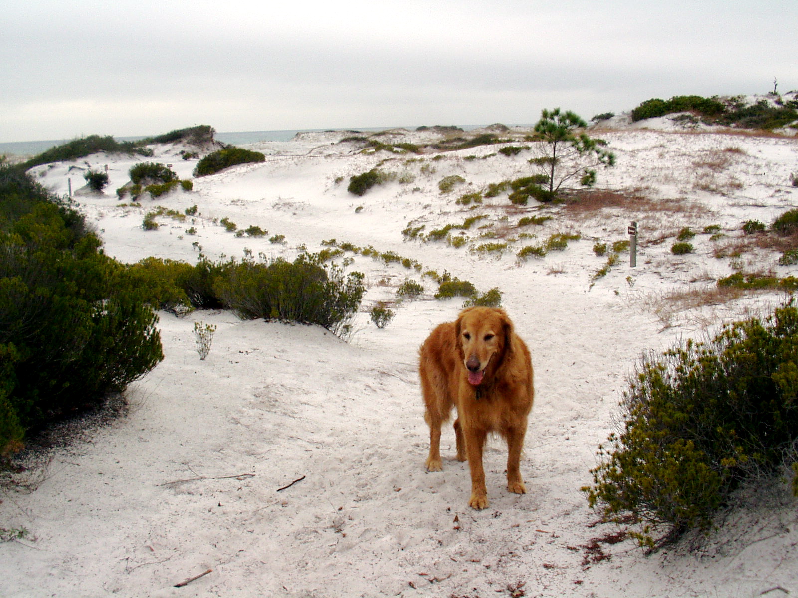
Topsail Hill is the best place that you can take your dog for an extended hike along the Gulf of Mexico. The trail of choice is the Morris Lake Nature Trail, a 2.5-mile balloon route laid out through ancient coastal dunes. The dunes trail is wide open and exposed to the elements so bring plenty of water for your dog on a hot day and since every step of the way is across glistening white soft sugar sand, your dog will get a workout any time of the year. In fact, look for iron tracks laid down during World War II that allowed heavy trucks to travel across the thick sand when these dunes were used as a bombing range. Morris Lake is one of three freshwater coastal dune lakes on the property. These rare oases are found only along the Gulf Coast in America and while tempting to visit for your dog, are inhabited by alligators. The trail climbs briefly into a Florida shrub community where your dog can find some shade among the sand pines and shrubby oaks before finishing along the Gulf of Mexico beach. If your dog isn’t spent from an hour on the Morris Lake dunes there is more hiking available in the other direction to Campbell Lake. This trail can also be accessed from the main entrance and campground and your dog won’t be allowed to finish the entire 5.2-mile loop (it tracks along the beach) but she can reach the broad, flat lakeside.

Where The Paw Meets The Earth: A trailmap and interpretive brochure can be found at the trailhead and directional signs decipher the faceless dunes.
Workout For Your Dog - Several hours possible
Swimming - Alligators live in the lake but your dog can step in to cool off.
Restrictions On Dogs - Dogs are allowed on the trails and in the campground but not on the beach.

Something Extra
In the days of sailing ships, turpentine was critical to the upkeep and preservation of wooden boats. The word turpentine derives from the terebinth tree, from whose sap the spirit was originally distilled. In early America, the tree of choice for turpentine was the old growth longleaf pines found across the South. To get the sap to flow, a deep V or “cat face” is cut into the side of a tree and gathered in a clay pot hung from a nail in the tree. The sap is then boiled and the turpentine residue collected. You can see cat face scars on trees still living in the preserve.

Phone Number - (850) 267-0299
Admission Fee - Vehicle entrance fee
Directions - Santa Rosa Beach; the main entrance is on CR 30A, one mile east of US 98, but the entrance of choice for most dog owners will be via Topsail Road from US 98, west of the junction with CR 30A.


The Hiking With Dogs group on Facebook is the place to post photos and info on your favorite canine hikes. Also get questions answered and find advice from members: join now

Wednesday, April 3, 2013

Corson’s Inlet State Park


places where you won't be able to wipe the wag off your dog's tail - Ocean City NJ


The Park
Corson’s Inlet was established in 1969 before every last inch of Jersey shorefront became developed. With its undisturbed sand dune systems and marine estuaries this is one of your last opportunities to experience the Atlantic oceanfront in New Jersey as it was before people discovered the shore.

The Walks
There aren’t many places where the hiking public is invited to walk across protected ocean dunes but Corson’s Inlet is one. Even rarer still is to find a dune system that permits dogs and again Corson’s Inlet is the place - from September 16 through March 31. The main trail (Yellow) leading away from the small parking lot beside the Rush Chattin Bridge between Ocean City and Strathmere and its two spur paths (Orange, then Red) all lead to the beach that can be used to create loop hikes on the hook-shaped peninsula. All canine hiking is on deep sugar sand and the trails are just long enough to be enjoyable without becoming laborious. If you come to Corson’s Inlet in late September or October on a hot day make sure to bring plenty of fresh water for your dog. Even though the trails aren’t long there is little shade among the dunes.

Where The Paw Meets The Earth: Sand
Workout For Your Dog - Yes, with ocean swimming and running in sand
Swimming - If the excitement of the Atlantic surf is too intimidating try the expansive crescent beach along the inlet with its calm, inviting waters
Restrictions On Dogs - No dogs between April 1 and September 15

Something Extra
America’s second-worst fire took place on a steamship called the General Slocum on New York’s East River in 1904 - more than 1,000 people perished. The steamer was salvaged and put back into service as a barge called the Maryland that sank off Corson’s Inlet on December 11, 1911. Buried beneath several feet of shifting sand searchers believe they have located the infamous General Slocum but there has been no definitive recovery.

Phone - (609) 861-2404
Admission Fee - None
Directions - Ocean City, Cape May County; from the Garden State Parkway use Exit 82 - Route 37 East/Seaside Heights. Take the jughandle to Fischer Boulevard and head north. Go right at the fourth light onto Cattus Island Boulevard; parking lot is on the left.


The Hiking With Dogs group on Facebook is the place to post photos and info on your favorite canine hikes. Also get questions answered and find advice from members: join now

Tuesday, April 2, 2013

Kellys Run Natural Area


places where you won't be able to wipe the wag off your dog's tail - Holtwood PA


The Park
The Pennsylvania Power and Light Company manages 5,000 acres of recreational land surrounding the Holtwood hydroelectric plant. You can camp, enjoy a picnic, play some ball, do a little fishing - or hike. There are 39 miles of marked trails along the lower Susquehanna, most on the long distance Mason-Dixon and Conestoga trails. Canine hikers will want to head for Kellys Run where the 6-mile trail system has been designated a National Recreation Trail.

The Walks
Starting out on the blue-blazed Kellys Run Trail you begin routinely enough at a picnic pavilion and drop quickly into airy woods of mature maples and poplar. Nothing special as you roll along. Then the trail drops abruptly and you are introduced to Kellys Run. Soon you are squeezing through thin avenues in a Wissahickon schist canyon as you follow the roiling stream down to the Susquehanna. In places where the rocks pinch the stream tightly enough, deep pools form to lure your dog in for a swim. After you reach the end of the run the character of this outing changes again. Old access roads are used
to climb relentlessly back to your car. Benches appear in the woods as if by magic in this leg of the hike. Your final steps will be through rolling farm fields and, finally, ballfields. Near the parking area, circling around Kellys Run Trail, is the 3/4-mile Oliver Patton Trail that was also named a National Recreation Trail in 1992. This lively little track, named for the original farmer on these hills, traverses a stand of Norway spruce and white pine planted by the power company.

Where The Paw Meets The Earth: Dirt woods and grass fields
Workout For Your Dog - Some major climbs lurking on these trails
Swimming - Kellys Run is mostly for splashing
Restrictions On Dogs - None
Something Extra
Several routes will take you out of the Kellys Run gorge up to the Pinnacle, a grassy picnic spot on a bluff more than 507 feet above Lake Aldred. The best route is the Conestoga Trail, carved by the Lancaster Hiking Club along the river. At the Pinnacle you can fill your dog bowl with water in season.

Phone - (800) 354-8383
Admission Fee - None
Directions - Holtwood, Lancaster County; the Holtwood Environmental Preserve stretches across both sides of the lower Susquehanna River. To reach Kellys Run turn on River Road (the first or last turn in Lancaster County) and make your first left onto Old Holtwood Road. The parking area for the preserve is on the right.


The Hiking With Dogs group on Facebook is the place to post photos and info on your favorite canine hikes. Also get questions answered and find advice from members: join now